K. Rules Clarifications
Table of Contents
What is the situation around Bali and Jawa Timur?
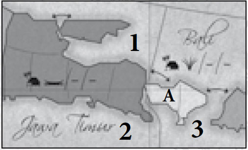
There are three different seas as shown on the picture - one sea north of Jawa Timur (number 1), one sea south of Jawa Timur (number 2), and one sea surrounding Bali (number 3). Sea 1 is not adjacent to sea 2, though both are adjacent to sea 3. The western area on Bali (area A) is adjacent to all three seas.
Maluku
Maluku covers all of the white islands and island clusters in the general region of the name Maluku on the map. One of the B city building cards which has Maluku shaded is missing shading from the topmost island cluster, but this is a misprint.
Symbols
The symbols indicate a region’s “potential” by era, with the eras separated by ‘/’. The symbol indicates either a production company, a shipping line, or a city. The hut is the mark for a city.
So let’s look at Java Barat:
In Era A, Java Barat will be on one or more of the city cards and there will be a rich production company available. In Era B, Java Barat will again be on one or more city cards and there will be a shipping company available. In Era C, Java Barat will be on one or more city cards, but no production/shipping companies in that region.
The dashes just indicate that nothing is available in that era. For example, Sumatra Barat:
In Era A, Sumatra Barat has no city cards or companies. In Era B, Sumatra Barat appears on one or more city cards and a rubber production company is available. In Era C, Sumatra Barat has no city cards or companies.
The marks help one realize where developments (cities or companies) will be available in future eras and are helpful for planning expansions.